
Page 59 - flip_2015_Canada_By_Train_The_Complete_VIA_Rail_Travel_Guide
P. 59
ROUTE GUIDE 169
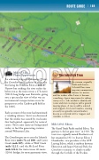
The Lobstick Tree
In a terrain originally thick with forests, Lobstick Trees were important communication devices for natives
and fur traders alike. Later, it became something of great importance for railway surveyors too, who needed to identify safe routes and river crossings as well as general meeting places. A tree would be selected and stripped of its lower branches, creating an easily recognisable natural marker, known as a lobstick, left for trappers and travellers to follow.
Mile 67-123: Photo Opportunity
For a distance of about 88 kilometres (55 mi), the Canadian crosses a series of rivers, the irst being the Pembina River at mile 67. Narrow but striking, the river rushes far below you as the train crosses a 274-metre (900-ft) long bridge near Entwistle, giving you a spectacular view of what was an instrumental transportation route for prospectors at the Cariboo gold ield in the 1860’s.
Early accounts of the route had mentioned a “smoking volcano,” but it was discovered that the smoke was caused by coal seams that had ignited, apparently by natural causes. hose same seams are being mined today, to fuel the generating stations around Wabamun Lake.
he Canadian goes on to cross the Lobstick River twice (miles 72 and 100), and Carrot Creek (mile 105), while at Wolf Creek (mile 122.1) and the McLeod River (mile 122.6) the train crosses 40-metre (120-ft) bridges, for more panoramic views.
Mile 129.6: Edson
he Grand Trunk Paciic reached Edson, “the gateway to the last great west,” in 1910. he town was originally named Heatherwood, but renamed in 1911 to honour Edson J. Chamberlin, vice-president of the GTP. Leaving Edson, which is midway between Edmonton and Jasper National Park, the Canadian continues to climb steadily through the foothills of the Rockies.
