
Page 60 - flip_2015_Canada_By_Train_The_Complete_VIA_Rail_Travel_Guide
P. 60
180 Toronto-Vancouver
Mile 50-56:
Photo Opportunity
Through Black Canyon, a dark and gloomy stage of the Thompson’s route, the train passes through several tunnels before crossing the river a mile 55. Between the tunnels you’ll see rushing rapids below you, with hoodoos towering in the distance to the west. At mile 56, the last spike on the Canadian Northern Pacific line was driven here on January 23, 1915. It was an occasion that attracted little attention at the time, unlike the celebration that had marked the completion of the Canadian Pacific Railway line, some 30 years earlier. Ten days later, a slide closed the new CNP line for nearly one year.
Mile 57.0: Basque Junction
The Basque-Mission stretch of the line sees some of the heaviest rail traffic in Canada. To speed up train movement, the country’s two largest rail companies agreed to allow directional running. So, from Mission, trains travelling from Vancouver are permitted to travel on the CPR line before switching to the CN line here (also, see page 183).
Mile 59-68:
Photo Opportunity
At mile 59, the Canadian speeds across
a 258-metre (849-ft) bridge some 21 metres (70 ft) above the Thompson River. It provides you with a chance to photograph some more stunning views of the river and its valley before the train enters the Martel tunnels, at miles 67.5 and 67.6. The tunnels are named after the 1855 proprietor of a nearby orchard, a Frenchman who is reputed to have buried his fortune in cans in his garden.
Mile 74.8: Spences Bridge
The area now known as Spences Bridge has long been an essential crossing point,
with native peoples taking advantage of these slow waters for centuries. It wasn’t until the Cariboo Gold Rush of the late 1860s that the first Europeans arrived.
At that time, the crossing point was known as Cook’s Ferry, after Mortimer Cook of the Hudson’s Bay Company, who had established a rope ferry some years earlier. The name changed in 1863 when engineer Thomas Spence constructed a bridge to complete the Cariboo Highway. As with the ferry that preceded it, a toll was charged for the use of the wooden structure. Spences Bridge is chiefly a farming community today, though the railway remains a key employer in the area.
Mile 80-95: Rainbow Canyon
Thanks to the natural features of the canyon walls, Rainbow Canyon was
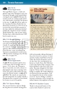
ffTTTTTfTTffTCPR & CN Tracks Interchange
The CPR and CN railways were key players in Canada’s rail expansion to the Pacific coast. Attesting to that relationship, their respective lines run parallel to each other for much of the journey from Kamloops to Mission, often on opposite sides of a river or canyon. Several times the tracks intersect, though this is chiefly for safety reasons. Avalanches and rock-slides are not uncommon and intersections allow trains to switch tracks to avoid blocked lines or hazardous stretches when there are warnings. Between Kamloops and and Boston Bar, 7.2 kilometres (4.5 mi) of slide detector fences, 28 bridges and 23 tunnels and snowsheds provide protection against the threat of these natural disasters.
