
Page 61 - flip_2015_Canada_By_Train_The_Complete_VIA_Rail_Travel_Guide
P. 61
ROUTE GUIDE 181
one of the most diicult and dangerous stretches of the transcontinental railway
to construct. he rock walls are stained with streaks of rusty red, giving the canyon distinctive splashes of colour, lending credence to its name. But the near-vertical drop of the rock face made the construction of tunnels, slidesheds and bridges a major engineering feat. With place-names like Jaws of Death Gorge (miles 85-90), Suicide Rapids (mile 87), and Cape Horn (mile 93), you can tell that it was no picnic for the workers either.
Mile 97: Lytton
he tiny town of Lytton is at the junction of the hompson and Fraser rivers.
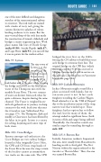
At mile 97.4, look below and to the west while crossing
the bridge and you’ll see the blue-green water of the Thompson mix with the muddy Fraser River. The two streams of water are distinct from each other for quite a distance, despite sharing the same channel. The Fraser is weighed heavy with silt gathered on its journey, in sharp contrast to the swift, fresh river that met the Canadian near Yellowhead Pass (see page 175). he hompson, dark and muddy at Clearwater, has been iltered by the lakes in its path. Lytton is a centre for rafting, kayaking and canoe trips of both rivers.
Mile 103: Cisco Bridges
Famous amongst rail enthusiasts, the Cisco Bridges are two railway bridges located at Siska (originally Cisco). Here, the CPR and CN lines swap banks of the Fraser River because the steep terrain of the locality cannot accommodate two tracks on the same side. The CPR
bridged the river first, in the 1880s, forcing the CN railway to build their truss arch bridge to continue their line. he original bridge on the CPR line (which was replaced in 1910) was moved to Niagara Canyon and is still in service on the Victoria-Courtenay line on Vancouver Island (see page 204).
Mile 109: Jackass Mountain
Jackass Mountain might sound like a place associated with hijinks, but we can assure you it is not. In fact, early freighters travelling the Cariboo Wagon Road referred to it as the “Hill of Despair” due to the treacherous nature of the steep, narrow trail that winded up it. hese freighters had no option but to follow the trail, but for many of them, the attempt ended in signiicant losses (both in terms of life and cargo) being sufered. Thankfully, the Canadian avoids any similar angst by tunneling through at mile 109.
Mile 125.3: Boston Bar
Initially, American residents frequented this area, most usually from Massachusetts, heading north to find gold. The First Nations within this region referred to the travelers as “Boston Men.” hus, the area was named Boston Bar.
